PROPOSED SOLUTIONS
We offer monitoring services of geotechnical structures like surveying systems, IP (In-Place) inclinometers, settlement and deformation sensors, including automatic and electronic systems. In cooperation with a technological partner specialized in measurement technologies for the construction industry, we implement even the most complex and innovative measurement systems, both in terms of design and in the execution part as well.
The main application areas of geotechnical monitoring:
- measurement of elements elongation;
- measurement of the distance change between elements;
- measuring the settlement of embankments;
- measurement of the force in piles;
- measuring the displacement of structure elements in relation to each other;
- measurement of deformation of elements;
- measurement of the crack width change;
- measuring change in the angle of inclination of any structure element;
- measurement of the settlement of supports;
- measuring inclinations from the vertical orientation;
- measurement of vibrations (amplitude, frequency);
- measurement of soil pressure on construction elements;
- measurement of concrete pressure on formwork;
- measurement of forces in ground anchors;
The measurements are taken using the following types of sensors:
- deformation sensors;
- displacement sensors;
- crack opening sensors;
- settlement sensors;
- pressure sensors;
- dynamometers;
- manual and automatic IP (In-Place) inclinometers;
- tilt sensors;
- pressure measuring sensors;
- vibration measuring sensors.
We cooperate with investors, designers and contractors of road works and technical infrastructure. A detailed analysis and experience of our employees allow us to choose the most favorable solution. Having knowledge of the soil parameters, investor's assumptions and exploitation requirements, our engineers prepare a project that meets the expectations of the investor, is economical and at the same time safe and complies with international standards and recommendations. Parallel the economic analysis and comparative analyzes will allow to identify the most valuable solution.
3D LASER SCANNER
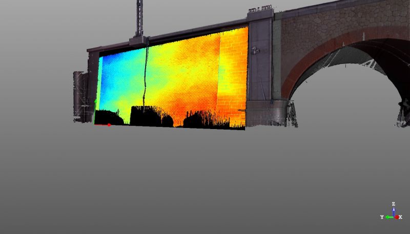
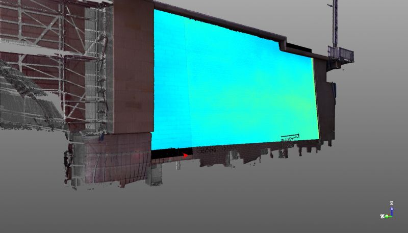
The 3D laser scanning technology is based on the non-selective measurement of a large number of points in three-dimensional space in real time. The distance is measured by calculation of the return time of the carrier wave reflected from the object. The result of the measurements is a spatial mapping of the surrounding reality, represented by a set of points with specific coordinates (point cloud).
Laser scanning makes it possible to perform situational and height measurements, and thanks to the cyclical successive measurements, it is possible to detect surface deformations of the tested object. The result of our work is a two-dimensional map of the scanned surface or a full three-dimensional digital model. The ability of quick detection of changes, which take place on a relatively large scanned area, makes the method of three-dimensional laser scanning currently very often used for monitoring structures.
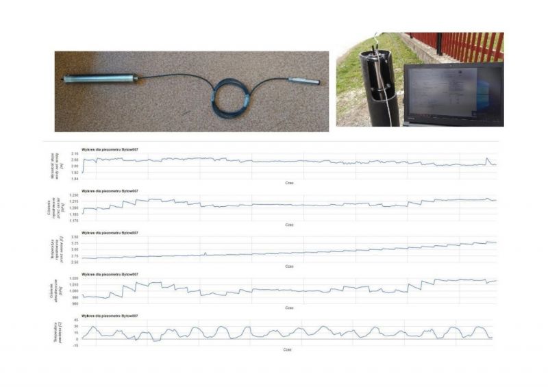
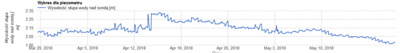
PIEZOMETER
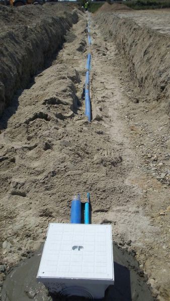
A piezometer is a small diameter plastic pipe installed in the ground. The subsurface part is usually sealed with a bentonite mixture, while the base of the piezometer ends with a filter through which groundwater enters the interior. The primary function of a piezometer is to show the level of groundwater. Installing a system of multiple piezometers allows you to recognize the circulation schema of the groundwater, indicating both the flow direction and its dynamics. Water samples for physico-chemical and microbiological tests can be taken directly from the piezometers. The content of nitrogens, chlorides, sulphates, potassium, sodium, calcium, iron or manganese is most often determined, what will allow to evaluate the degree and type of contamination of groundwater.
Piezometers are installed in locations, where is a need to identify the impact of water conditions on building structures, i.e. in investment areas where water levels are decreasing or in areas exposed to flooding. Areas particularly predestined for piezometric monitoring are also areas with risk of groundwater contamination.
We install and service piezometers of any depth. We perform both manual measurements and fully automatic systems, recording and reporting water levels in an on-line system. Automatic systems are especially recommended for monitoring systems consisting of many piezometers over a large area, because they allow quick and at any time evaluation of the hydrological conditions in the studied area.
INCLINOMETER
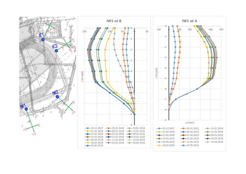
Inclinometers are sensors of displacements registered on the basis of changes in angular deflection. The direction of the inclinometer on installation directly determines the measuring possibilities. The horizontal inclinometers are used to register vertical displacements, i.e. subsidence or rise of the terrain. Vertical inclinometers enable the recording of lateral displacements. Using this type of measurements, for example, the push out of the substrate in the proximity of the embankment construction or deformation of retaining walls is determined. Using vertical inclinometers, it is also possible to identify slip surfaces in landslide risk areas.
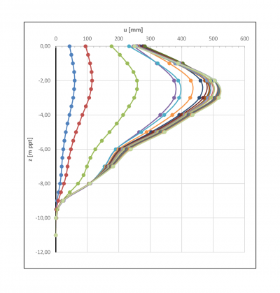
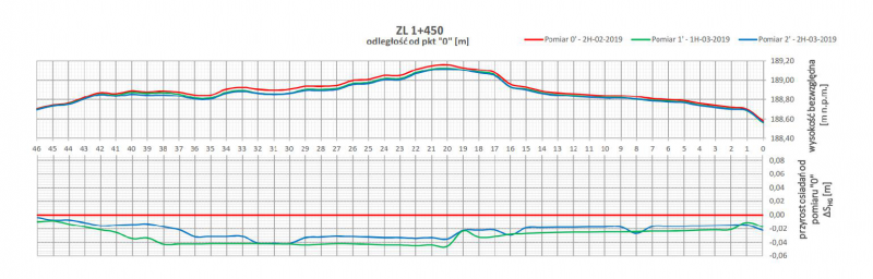
The combination of measurements made with vertical and horizontal inclinometers gives a particularly wide range of possibilities in the case of using the observation method of construction, recommended by Eurocode 7. This method is recommended for structures constructed in areas of weak soil. The idea is to perform observations of displacements, which may be the basis for introducing corrections of a pre-designed solution. Parallel registration of settlements and side push out allows to evaluate the safety of the constructed embankment, and observation of settlements in a specific time interval allows to assess the status of the consolidation process. The measurement can be performed manually or automatically, thanks to the installation of automatic IPI inclinometers. Such a system enables automatic data recording and reporting in the on-line system at any time interval specified by the user.
HYDRO PROFILE METERS (HYDROSTATIC PROFILE METER)
The hydroprofilemeter is a hydraulic settlement measurement system that enables registration of deformation along the installed hydroprofilemeter string. The system consists of a guide tube installed in the ground and a portable probe.
During the measurement, the principle of hydrostatic leveling is used - measurement of the hydrostatic pressure generated by the liquid column ended with a probe. The vertical position of the analyzed point is determined by converting the increase of pressure compared with the reference value to the liquid column height. By linking the measurements to the control benchmarks located outside the impact zone of the structure, it is possible to obtain an accurate outlook of absolute settlements.